 Catchment Management
 The James Hutton Institute
This page is no longer updated. The Macaulay Land Use Research Institute joined forces with SCRI on 1 April 2011 to create The James Hutton Institute.
Allt a' Mharcaidh Catchment
Bulk Deposition Chemistry
Click on map to enlarge
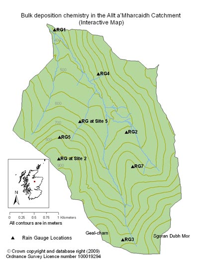
The quality and quantity of bulk deposition is monitored at the site using standard 12" ground level gauges. In 1986 five ground level rain gauges (RG 1,2,3,4,5,) were located at selected sites within the catchment that represent differences in altitude, topography and aspect.
In 1990, the original experimental design was modified to account for an area of the catchment that was exposed, north facing and with no instrumentation. A bulk deposition collector was introduced to the existing network of collectors at 760 m (RG 7).
Sampling at RG1 stopped in 1990 and restarted in 1998. Following the completion of the deposition study in 1997, most of the bulk deposition gauges were removed but long term monitoring of bulk deposition continues at site 2 (RG2 at the AWS) and at deposition gauge 1 near the stream outflow.
To access the data charts click on interactive chart or use the list below:
Analytical data were rejected from the study when there was evidence of contamination from birds (i.e. phosphate concentrations >0.5 mgl-1, potassium >0.2 mgl-1, nitrogen species >0.5 mgl-1). No observation was rejected as long as the sum base cations (Mg, Na, K, Ca, H, NH4-N) / sum of acid anions (SO4-S, NO3-N, Cl) was within a ± 10 % error for that individual sample
|
Updated: 23 Jan 2024, Content by: RH
|