 Catchment Management
 The James Hutton Institute
This page is no longer updated. The Macaulay Land Use Research Institute joined forces with SCRI on 1 April 2011 to create The James Hutton Institute.
Allt a' Mharcaidh Catchment
Soil Descriptions
| Drift Type | Component Soils |
|---|---|
| Moraine | Humus-iron podzols, Peaty podzols, Peaty rankers |
| Moraine | Humus-iron podzols, Peaty podzols, Deep peat |
| Till, Moraine | Peaty podzols |
| Till, Colluvium | Peaty podzols, Peaty rankers |
| Till | Subalpine podzols |
| Cryic | Alpine podzols |
| Cryic | Alpine podzols |
| Moraine | Alpine podzols, Alpine podzolic rankers |
| Cryic | Alpine podzols, Alpine gleyed podzols |
| Organic, Colluvium | Peaty rankers |
| Organic | Shallow blanket peat (50 – 100 cm) |
| Organic | Eroded shallow blanket peat (50 – 100 cm) |
| Organic | Deep blanket peat (> 1m) |
| Organic | Eroded deep blanket peat (> 1m) |
| Organic | Shallow high-level blanket peat (50 – 100 cm) |
| Organic | Eroded shallow high-level blanket peat (50 – 100 cm) |
| Organic | Deep high-level blanket peat (> 1m) |
| Organic | Eroded deep high level blanket peat (> 1m) |
| Alluvium, Colluvium, Organic | Humus-iron podzols, Peaty podzols |
| Scree | Scree |
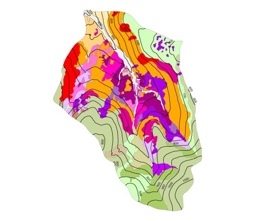
The soils of the catchment were mapped by Nolan et al (1985) and classified according to the method used by the Soil Survey of Scotland Staff (1984). The majority of soil types are developed on granitic parent material of the Countesswells Association, with the exception of the organic and alluvial soils. Fifteen soil taxonomic units (types) were identified in the catchment, these fall into three broad categories; alpine soils (including alpine podzols, alpine rankers and alpine gley soils); podzolic soils (including peaty podzols, humus iron podzols and subalpine podzols); and organic soils (including deep and shallow blanket peats and peaty rankers).
Alpine (or oroarctic) soils are distributed at high altitudes above 750m and organic soils are mainly confined to the valley floor and extend along the main stream tributaries. Podzolic soils are found on the slopes between the organic soils at low altitudes and the alpine soils at the high altitudes. The distribution of general soil types within the catchment is illustrated here.
Soil analysis
Soil analysis including profile descriptions, particle size distribution, exchangeable cations, pH, %C, %N, sulphur dynamics and mineralogy is available from the detail survey carried out at the 1:10,000 scale. Further details on the soils in the catchment can be found here.
|
Updated: 23 Jan 2024, Content by: RH
|