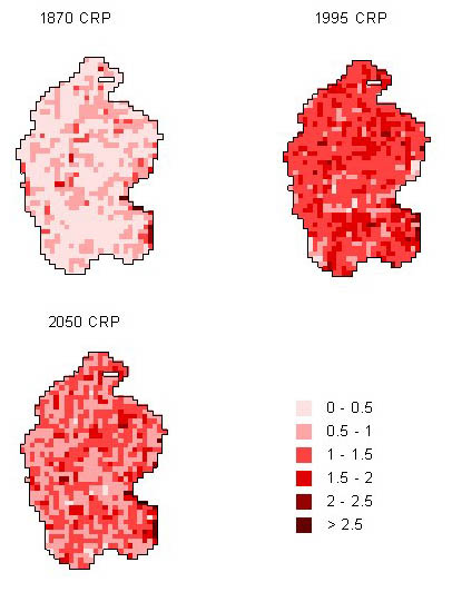
The net uptake of nutrients by the forest biomass (trees) was estimated by multiplying the annual stem volume growth by the bulk density and element concentrations of stem with bark. A non-linear function was fitted to the data, to explain the average stem volume growth of the three tree species with stand age. The grid-specific simulation of net nitrogen uptake (kg ha-1 a-1) of the Kangasvaara catchment is here shown as an example of the model inputs.
Grid-specific nitrogen uptake (kg ha-1 a-1) values in 1870, 1995 and 2050 in the Kangasvaara catchment were applied as input parameters to the GISSMART model. The size of a grid was 25 x 25 m2.
Reference
Bilaletdin, Ä., Lepistö, A., Finer, L., Forsius, M., Homberg, M., Kämäri, J., Mäkelä, H. & Varjo, V. 1999. Development of a regional GIS-based model to predict long-term responses of soil and water chemistry to deposition and nutrient uptake scenarios. Water, Air and Soil Pollution. Manuscript.
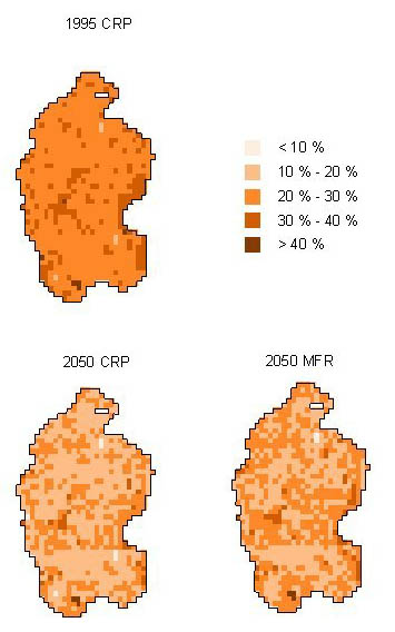
The GISSMART model simulates soil chemistry both dynamically and spatially. To reproduce grid-specific estimates of present base saturation values, the weathering rate values were calibrated. The areal distribution of base saturation values was rather even throughout the simulation period. The decrease in BS over the years follows from the assumed temporal development of the acidifying deposition. In the future, the low-deposition scenario (MFR) gives slightly higher base saturation values than the scenario based on current reduction plans (CRP).
Grid-specific base saturation values (BS), %, in 1995 and 2050 (CRP=Current Reduction Plan scenario and MFR=Maximum Feasible Reduction scenario) in the Kangasvaara catchment, calculated by GISSMART. The size of a grid was 25 x 25 m2 (scroll down).
Reference
Bilaletdin, Ä., Lepistö, A., Finer, L., Forsius, M., Homberg, M., Kämäri, J., Mäkelä, H. & Varjo, V. 1999. Development of a regional GIS-based model to predict long-term responses of soil and water chemistry to deposition and nutrient uptake scenarios. Water, Air and Soil Pollution. Manuscript.