 Following the use of the MERLIN model to identify generic responses of forest growth dynamics during rotation of commercial forest crops, a MAGIC regional application was conducted using data from sixty lochs and their catchments in Galloway region, SW Scotland. Data collected include regional surveys of water quality over the period 1978-1994, detailed history of land use change, and soils data from the soils data base held at the
Macaulay Land Use Research Institute. Forest data was incorporated which represent the age and extent of afforestation in each individual catchment and any historical changes.
Following the use of the MERLIN model to identify generic responses of forest growth dynamics during rotation of commercial forest crops, a MAGIC regional application was conducted using data from sixty lochs and their catchments in Galloway region, SW Scotland. Data collected include regional surveys of water quality over the period 1978-1994, detailed history of land use change, and soils data from the soils data base held at the
Macaulay Land Use Research Institute. Forest data was incorporated which represent the age and extent of afforestation in each individual catchment and any historical changes.
Background
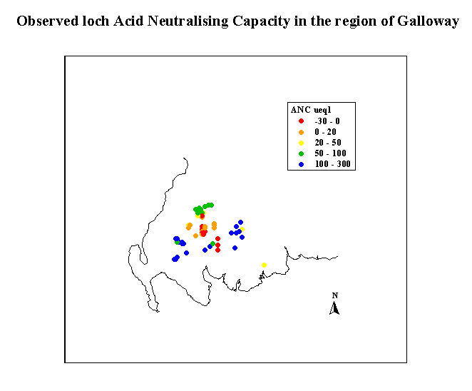
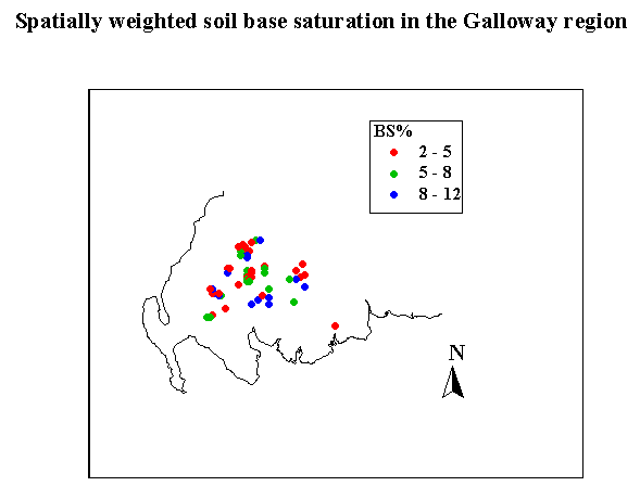
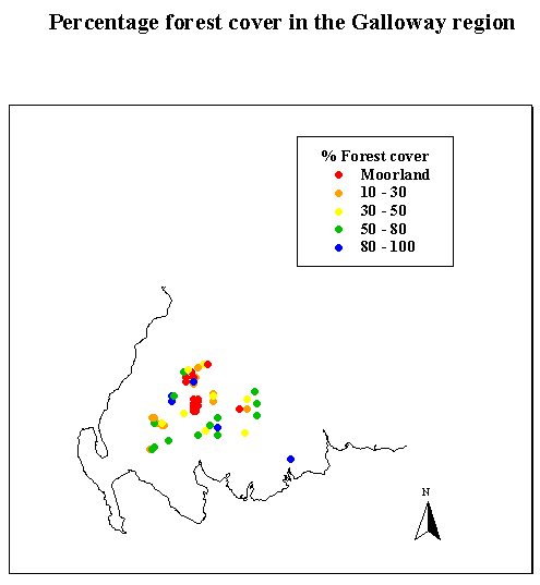
Decades of acid deposition in the Galloway region of south-west Scotland have resulted in acidification of surface waters and damage to aquatic life. The spatial distribution of mean (1996-97) Acid Neutralising Capacity (ANC) is shown in Figure 1. This region is characterised by highly silicious granitic bedrock covered by blanket peat, typically 50-100cm in thickness, developed on the higher plateaux. Podzolic soils dominate on the hill slopes, and alpine soils dominate at higher elevations. Generally, the soils are acidic (Figure 2) with a limited capacity to neutralise acid inputs from the atmosphere (Ferrier et al., 1995). Vegetation is predominantly moorland although large scale commercial forestry commenced in the 1940s (Figure 3) and this has exacerbated the acidification problems as a result of :
Future afforestation policy is expected to have a significant effect on acidification status. Two forestry scenarios have been implemented in the model simulations namely:
Reference
Ferrier, R.C, Jenkins, A., Cosby, B.J., Helliwell, R.C., Wright, R.F., and Bulger, A.J (1995) Effects of future N deposition scenarios on the Galloway region of SW Scotland using a coupled sulphur and nitrogen model (MAGIC-WAND). Water, Air and Soil Pollution 85: 707-712.