New Landcover of Scotland
 The James Hutton Institute
This page is no longer updated. The Macaulay Land Use Research Institute joined forces with SCRI joined forces on 1 April 2011 to create The James Hutton Institute.
 This page has been mothballed.
It is no longer being updated but we've left it here for reference.
New Land Cover of Scotland - Current Position (Technical)
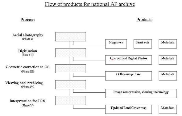
The initial aim of the New Land Cover of Scotland Project Steering Group is to create an up-to-date high resolution map related image of the entire land area of Scotland that can be easily accessed and available in digital form.Five stages of the path to a land cover map, with associated costs, have been identified:
| Stages | Description | Specification | Metadata | Costs |
|---|---|---|---|---|
| Phase I | Aerial photography acquisition | Colour emulsion Ground resolution: rural - 1.0 metre (1:25,000) urban - 0.25 metre (1:10,000) or ‘hybrid’ |
Flight plans e.g. GPS Camera calibration |
a) £750k (1:20,000) b) £450k (1:1,250 to 1:10,000, b/w emulsion) c) £600k (1:20,000) d) £445k (1:20,000) |
| Phase II | The digitisation of the aerial photos | 1200 dpi All prints |
Print details Negative details Sortie info |
a) NA b) £177k c) £400k d) NA |
| Phase III | The ortho-rectification and mosiacing of the digital images to create digital ortho-image base (i.e. photos with map quality positioning and accuracy) | Colour balanced 2 metre accuracy |
Print info Sortie info OS source |
a) £1.5m b) NA c) £2.5m d) £600k |
| Phase VI | The provision of a viewing package that will facilitate the compression and the large quantities of digital data | NA | ||
| Phase V | The creation of the new Land Cover of Scotland map | Unknown | Unknown |
Costs a), b), c) & d) represent the quotes for the various phases from different commercial companies.
These outline costs can be defrayed not only between consortium members but also through sales to users in the public and private sector. The actual cost to the departments and agencies will depend on the number of key players that are prepared to sponsor the setting up of the project and the nature of the public/private partnership. Some departments may be able to identify cost savings as this project would save repeat aerial survey and some field checking projects. Sponsors who commit at the start of the project can expect cost advantages.
Figure 1 illustrates the sequence of the flow of products in Phases I to V.