FEARLUS Version 0-5
FEARLUS Model 0-5 Ontology
Model 0-5 is an abstract model of land use change containing a few enhancements to model 0-3. These enhancements allow different kinds of regular grids of cells to be simulated than just squares, the use of strategies in decision algorithms that can look back over more than just the previous year's data, and the availability of strategies that use the physical neighbourhood rather than the social neighbourhood. A new clumping algorithm is also available in model 0-5, and land managers can be initialised with more than one land parcel in year 0.
This page contains more details on the enhancements. Refer to the model 0-3 page for information on the model schedule, which remains unchanged.
Clumping Algorithms
The Cellular Automaton clumping algorithm used in model 0-3 does not necessarily maintain the same proportion of 1s and 0s across the space. Model 0-5 allows the user to select a new clumping algorithm instead, that is designed to maintain the proportion of 1s and 0s across the space. This clumper can be configured to clump only the first n bits of the land parcel bit string. The algorithm is as follows:
- Make a list ZERO-LIST of all the land parcels with value 0, in random order
- Make a list ONE-LIST of all the and parcels with value 1, in random order
- Let LP-A be the first item in ZERO-LIST
- Search in ONE-LIST for a land parcel LP-B to swap values with that matches
one of the following criteria:
- One spatial arrangement of 1s and 0s SPACE-1 is more clumped than another
SPACE-2 if:
- The number of von Neumann boundaries between land parcels with both land parcels having the same value in SPACE-1, VNEQ-1 is greater than that in SPACE-2, VNEQ-2
- If VNEQ-1 = VNEQ-2, then if the number of diagonal boundaries between land parcels with both cells having the same value in SPACE-1 is greater than that in SPACE-2.
- One spatial arrangement of 1s and 0s SPACE-1 is more clumped than another
SPACE-2 if:
- If the search is successful, then set LP-A's value to 1, LP-B's value to 0, put LP-A onto the end of ONE-LIST, and LP-B onto the end of ZERO-LIST, and continue from step 3.
- Set LP-A to the next item of ZERO-LIST. Stop if ZERO-LIST has no more members.
- Repeat from step 4.
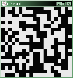
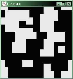
The two clumping algorithms are compared in the diagram below:
 |
|
| The first bit of each land parcel's bit string before clumping is applied | |
 |
 |
| The first bit of each land parcel's bit string after 6
cycles of the CA Clumper (Further cycles make no difference) |
The first bit of each land parcel's bit string after applying the new clumper maintaining the same proportion of 1s and 0s |
Initialisation
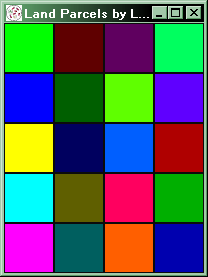
In model 0-3, land managers were initialised with one land parcel each in year 0. The model now has two new parameters, Number of initial horizontal land parcels and Number of initial vertical land parcels that determine the initial allocation of land parcels to land managers. The following diagram shows the difference:
 |
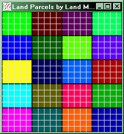 |
| A 4 by 5 environment with land managers initialised with one land parcel each | A 20 by 20 environment with land managers initialised with 5 by 4 land parcels each |
Environment Types
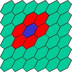
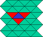
Model 0-5 introduces the cylindrical topology, which is wrapped around in one dimension (like the toroidal topology) and bounded in the other (like the planar topology). Also introduced are triangular and hexagonal neighbourhoods. These simulate a grid of triangles (or hexagons) on a grid of squares by using special neighbourhood envelopes. The following diagram illustrates this:
 |
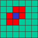 |
| The hexagonal grid on the left can be simulated in the grid of squares on the right using the neighbourhood envelope indicated in red. | |
 |
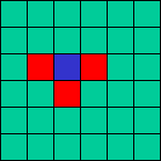 |
| The triangular grid on the left can be simulated in the grid of squares on the right using the neighbourhood envelope indicated in red. Note that the envelope will change in alternate squares, as the triangles alternate between pointing up and pointing down. Note also that topological inconsistencies occur with odd numbers of horizontal or vertical cells if a triangular grid is simulated on a toroidal topology. | |
The radius parameter is introduced in model 0-5, which allows for larger physical neighbourhoods. There is also a global topology in which each cell is a neighbour of every other cell.
Strategies
A greater range of strategies is possible with model 0-5, as functionality is provided for creating strategies that inspect the physical rather than social neighbourhood when imitating. Facilities are also introduced that allow land managers to have a specified length of memory. This is specified at the subpopulation level. Land managers are capable of recalling the land use, yield, climate and economy from previous years.

