Remote Sensing
As part of the process of low-cost site characterisation we investigated the use of medium-format metric photography and videography.
Our interest in aerial photography was in some ways a return to earlier experimentation carried out at MLURI in the early 1980's. This work had used a light aircraft fitted with a rig containing a 70mm format Hassleblad camera to collect land cover information using black and white, colour and infra-red film. Since the 1980's the focus had turned towards satellite-based systems dealing with much larger areas than are the focus for the LADSS project. Aerial photography in Scotland has a significant advantage over satellite-based systems in the number of days on which imagery may be collected, as even with a continuous covering of high-level cloud, acceptable, quality imagery can be obtained. The spatial resolution of imagery obtained from the aerial photography may also be greater than that from satellite systems.
For the LADSS test sites coverage was obtained using a Rolleiflex 6006 metric camera with a Planar f2.8/80mm lens, in a modified mount fitted to a light aircraft.


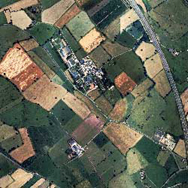
- section of Newton Rigg.
From a practical point of view the processing of coverage from raw photographs into an ortho-rectified product (images registered to a map base with distortions removed) was greatly simplified by the introduction of Erdas Orthobase.
As an alternative to the infrared photography collected previously we decided to use a digital video system. This complements the metric film camera by adding a further band of information (known to be useful in land use applications) in a single survey pass, as the video camera is mounted in a second smaller housing attached to the door of the aircraft.
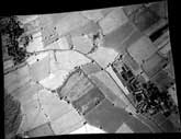
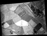
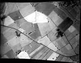 Sequence of orthorectified IR videography for Newton Rigg.
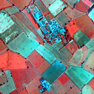
The video camera used was a PULNiX TM-756I (2/3 inch ccd array 756x581) with a Cosmicar f1.5/8.5mm lens filtered using a Kodak Wratten 88a filter. The data were recorded on a Sony GV-S50E portable Video8 recorder. Individual frames were captured using the SnapMagic frame-grabber and then processed again using Erdas Orthobase.
For more information on the data fusion process of combining the photography with the video data see the study Combining Metric Aerial Photography and Near-infrared Videography to Define Within-field Soil Sampling Frameworks.


