 Workshops
 The James Hutton Institute
This page is no longer updated. The Macaulay Land Use Research Institute joined forces with SCRI joined forces on 1 April 2011 to create The James Hutton Institute.
 This page has been mothballed.
It is no longer being updated but we've left it here for reference.
WoodDeer Workshop - 29th November 2001
Summary Report
1. Introduction
A workshop on the end-user requirements for WoodDeer (a decision support system for managing deer in woodlands in the uplands of Scotland) was held at the Macaulay Land Use Research Institute on Thursday 29th November 2001. Participants from a wide range of backgrounds including forestry, stalking, estate and woodland management, science and conservation, discussed the issues surrounding the management of deer in woodlands and how these could be addressed by a decision support tool.
Macaulay Land Use Research Institute
16 Jan 2002
2. Executive Summary
Deer management problems occur in all areas and at all scales and include issues for all deer species; all woodland types and open hill areas; lowland as well as upland areas; and at scales ranging from single plots of 1 hectare to entire deer ranges of 100,000+ hectares.
Problems were found in two entirely different spheres - what might be called the 'political' and the 'technical' spheres:
- Political: it was generally felt that deer management was best addressed at the scale of the deer range as the immigration and emigration of deer in smaller areas (both in the short and long term) was too large a factor to be ignored. Thus, management objectives had to be set within Deer Management Groups (which have been set up for just this purpose). A large problem is in resolving conflicting interests across a DMG and in agreeing a management strategy that will actually be implemented, and will actually work. However, local management issues could not be ignored.
- Technical: at the practical level there are problems in determining how many deer are present in an area, what an appropriate number of deer should be for any given area, and what is the most cost effective method of managing the deer to bring their numbers to the appropriate level and to keep them there.
3. The Problem
Woodlands are managed at an enormous range of scales - from single hectare plots through to 100,000+ hectares of forestry. One estimate was that there are some 48,000 private woodland owners in the UK with an average woodland area of 10 hectares. However deer ranges are not generally restricted by woodland boundaries, and thus managing the deer must be addressed at a Deer Management Group scale.
This requirement causes one of the largest problems - the political one of resolving conflicting interests and objectives in agreeing a management strategy for a Deer Management Group. Part of this is the conflict with those not participating in the Deer Management Groups for their wider area - as such participation is not mandatory. Setting a single management strategy will generally not allow all objectives to be met.
The time scale over which management is required also varies: from the 'instantaneous' effects of culls on a population and the knock-on effect the following year; through the effect of a deer population on a given woodland plot over a 5 year Woodland Grant Scheme (WGS) application timescale; on to the 10-15 year time scales required to allow a regeneration zone to reach a robust state and to 20 years and beyond when looking at the effect of damage to the value of timber.
There are a number of more technical problems which were reported consistently - these include:
- determining the number of deer in a given area at a given time, or over a period (the counting problem);
- predicting the impact that any given population will have on an area - particularly on the sensitive regeneration areas, and in determining what level of deer population will allow regeneration to occur (the impact problem);
- determining the most cost-effective way (while satisfying multiple objectives) of managing the deer (both within a management group - generally through culling, and at a local level, through fencing and other methods) of getting the deer population to a desired level and keeping it there (the management problem).
4. Current Methods of Deer Management
Although there are no doubt exceptions to the rule, there appeared to be three main ways of managing deer in woodlands - the use of fencing, the 'Trial and Error' approach (also dubbed the 'keep shooting until the trees grow' approach) and the Forestry Commission 'Count and Cull' approach.
Fencing
Although generally successful in protecting stands of saplings from deer impacts, fencing is 'out of vogue' for several reasons - initial and maintenance cost, impact on wildlife - particularly bird strikes, opposition from walkers etc., and is politically out of favour.
Trial and Error
In brief - if the level of damage to trees within the wood is too high, the number of deer culled is increased until the level of damage is acceptable. This approach is adopted for a number of reasons but mainly because of the lack of an affordable alternative.
The main advantage of this method is that it requires no data gathering - apart from the damage assessments, and relies on the knowledge and experience of the stalkers involved.
The main disadvantages are the uncertainty in the amount of time and effort required until it works, and the fact that it usually only addresses an immediate local issue unless co-ordinated within a DMG.
Count and Cull
The Forestry Commission in the guise of its commercial branch Forest Enterprise and working with the research branch Forest Research have put a lot of effort into various methods of counting deer in woodlands, damage assessments, using population models to help set cull targets and the monitoring of cull success and feedback of data from culls into the population models. The process works reasonably well but is limited by difficulty of obtaining the required data and the fact that the models ignore deer movements and do not work at small spatial scales or include open hill areas. It may be that such an approach is only possible for a large organisation like the FC.
Other methods
Various other methods were noted, such as diversionary feeding and sterilisation but these were not widely known or experienced and there was a general feeling that 'theory was better than practice'.
5. Available Data
There was a mix of views on the amount of data available - perhaps reflecting the individual differences between various participants and organisations. Some felt that there was quite a lot of data available (particularly those involved in forestry), while others were of the opinion that there was very little data for their local area.
Various sources of data were cited but all varied in detail from place to place:
- cull, shooting and larder records were the most common;
- some had quarterly counts within the management area (woodland plots);
- some had dung counts;
- some limited information on damage to trees, often used informally;
- some tree survival rates in restocked areas;
- most (via DCS) have deer counts, but with uncertain accuracy in woodland.
6. Tool Requirements
There was a general feeling that some sort of decision support tool would be useful - probably because it was universally acknowledge that the current methods were inadequate or only partially successful and so anything which could help would be a useful improvement.
However, there was no clear consensus on what such a tool should do. There was a widespread feeling that it should address deer management at a range of scales (both spatial and temporal) and that it should not be restricted to a single woodland type or deer species, or indeed ignore open hill areas. This is perhaps indicative of the general view that deer management needs to be addressed at the DMG level (or above) as well as locally. However, there were several indications that a tool, which was not locally applicable, may not gain much support.
Specific requirements that were mentioned include:
- Should operate at a scale relevant to the local deer population and its movements.
- Need to consider both natural woodland and forestry.
- Management needs to be at the scale of the full range of the deer.
- Provide culling targets, especially in relatively closed systems
- Speed up the trial and error process of setting the cull
- Planning of cull strategies over a number of holdings/DMG
- Should cope with immigration and emigration.
- Should include a cost-benefit analysis, i.e. the costs of culling v. the regrowth achieved
- Need to predict threshold population size for different stages of regrowth
- To be flexible enough to plan 2nd rotation felling and replanting
- Needs to include a model of forest dynamics and tree growth
- It has to be transparent in the output and in the assumptions that are built into it.
- Tool must be spatial.
- Tool should provide predictions in a range of areas:
- deer population levels over (say) 5 year timescales
- deer weights
- tree and other vegetation impacts
- deer density required for regeneration
- effect on deer of requirements for regeneration
- It would need to help co-operation between neighbouring landowners/different organisations.
- Should predict deer movements (esp. open hill - woodland) and behaviour (esp. if they change in response to culling method etc.).
- Should provide 'goal seeking' - to find appropriate culling level for a required outcome.
- Model needs to be user friendly ('more than HillDeer') and intuitive.
- Needs to be labour-saving, so that it clearly saves time and effort - esp. if time/money spent to collect data for input and/or to pay for the tool.
- Needs also to clearly demonstrate benefits - i.e. use of model to guide management produces better outcome than previous approach/efforts.
- Helping the dialogue between agencies and practitioners
- Supplementing local knowledge.
- Cost of development.
- Quality/Quantity of data required - and cost to gather.
7. Training and Knowledge Exchange
There was also a view expressed that training should form part of the overall 'package'. It was generally recognised that there was a lack of both knowledge and training for management and a lack of good information to help make decisions. As well as a lack of knowledge on how many deer there are and where they are in woodlands, there was also felt to be a lack of understanding of deer behaviour in woodlands and linked to this was a problem in predicting how and when deer move between open hill and woodland and how/when they then become hefted to woodland rather than the open hill.
In addition to training in deer behaviour, it was widely accepted that there ought to be training in methods of counting deer, dung counts, and damage assessments - in particular with some standardised methods so that data can be usefully compared and/or used in appropriate tools.
Finally, training in the use of the tool itself should be included as part of the package.
8. WoodDeer
The whole concept of what WoodDeer is has shifted in response to the workshop. In particular, the scope of WoodDeer (or whatever it will be called) is no longer restricted to native woodland - but also includes plantation and indeed open hill areas. There is a requirement to answer questions specific to small local areas as well as across entire deer ranges, and from predicting instantaneous and short-term impacts to those in the long-term over 20 years and more. From an implementation point of view WoodDeer will not be a single ecology model - but rather a framework in which we can link models and other components (such as information sources, training materials and so on) as required to build a range of applications to meet specific individual requirements - e.g. to answer Woodland Grant Scheme questions for specific sites.
Where next ?
The Macaulay Land Use Research Institute will continue to consult with potential users of the system to ascertain which specific applications are most important/urgent and will produce an initial framework design and application list for further consideration by a Steering Group and the wider community [by October 2002].
We will invite other groups/agencies to collaborate with us in designing a framework and in producing specific applications and other components of the system, and indeed with individual application users [by March 2002].
We will endeavour to produce an initial framework and some useful applications as soon as is reasonably possible - with the plan of developing the system to produce further applications and components on an ongoing basis. We would expect to produce some immediately useful parts of the system (e.g. some parts of the Information and Training Resources) in a fairly early version of the system (within 1 year) and further applications over the next 18 months to two years.
Proposed system
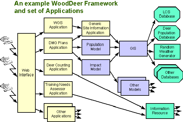
Without wishing to prejudge any subsequent analysis work or feedback, it is probably worth providing a diagram of how the system may fit together in order to prompt immediate feedback on the ideas.
In this example a few specific applications are linked into a set of models (which may be process models or expert systems), a Geographical Information System (GIS) for ease of getting spatial and other data for the models, and various databases. The applications are accessed via a web based front-end, and in the example, are as follows:
- Woodland Grant Scheme Application - to provide probability levels of successfully meeting WGS requirements for any given site based on user-supplied deer density estimates and site location and vegetation and structure information derived from a GIS.
- Deer Management Group Plans Application - to provide cull targets to achieve stated DMG deer population levels based on current and historical deer counts.
- Deer Counting Application - to provide information on counting techniques (dung counting transects, damage assessment, population census techniques etc), and an estimator to allow conversion of raw data into population estimates.
- Training Needs Assessor Application - to enable users to determine their training needs and link to appropriate training sources (e.g. standard or bespoke training courses and providers).
9. Feedback
Any comments, suggestions or requests for more information should be sent to:
Jim McLeod
Land Use Systems
The Macaulay Land Use Research Institute
Craigiebuckler
Aberdeen AB15 8QH
Tel: 01224 395000
Fax: 01224 311556
Web: www.macaulay.ac.uk
Email WoodDeer@macaulay.ac.uk
Annexe 1. Workshop Participants
| Adam Wallace | The Woodland Trust Scotland |
| Alison Hester | Macaulay Land Use Research Institute |
| Colin Lavin | Forest Enterprise |
| Dave Goffin | DCS |
| David Elston | BioSS |
| Douglas Clark | Forestry Commission |
| Douglas Worrall | CSCT |
| Dugald Foreman | Strutt & Parker |
| Duncan Stone | SNH |
| Eoin Smith | Glen Tanar Estate |
| Ewen Cameron | SNH |
| Helen Armstrong | Forest Research |
| Iain Gordon | Macaulay Land Use Research Institute |
| Iain Wright | Macaulay Land Use Research Institute |
| Irvine Ross | The Ross Partnership |
| Jim Lauder | Forest Enterprise |
| Jim McLeod | Macaulay Land Use Research Institute |
| John Morgan | Forest Enterprise |
| Michael Bruce | Timber Growers Association |
| Richard Cooke | ADMG |
| Robin Pakeman | Macaulay Land Use Research Institute |
| Steve Palmer | CEH |
Annexe 2. Consolidated Discussion Group Summaries
Current deer/woodland problems and scale
- Scale of management may range from 1 ha to 000's of ha.
- Establishment appears to be the main woodland phase where deer are causing problems
- Some local problems with bark stripping in plantations
- Also problems in restructuring current woodland or plantations. Small areas of regrowth targeted by the deer, and the introduced species are often highly preferred by deer compared to Sitka.
- Cost of separating deer from trees - fencing being the most common option
- Cost of deer control is high, at approx. £100 per culled animal (net of value of carcass). This translates into £8-9/ha.
- There can be conflict of objectives between estates/managers e.g. conflict between stalking interests and forestry objectives. How to reconcile these conflicts.
- Cannot consider natural woodland and forestry separately. Nature woodland might be wanted for timber production.
- Management needs to be at the scale of the full range of the deer.
- There is a lack of quality information and data for management.
- Areas of interest for woodland management range from c.100 - 500 ha up to 100,000+ ha
- However, all recognise that deer management must be at level of the deer range (i.e. at Deer Management Group [DMG] level)
- Main problem is in agreeing management objectives at DMG level
- Also a lack of knowledge/training
- Key problem stage in relation to deer was agreed to be establishment phase.
- Damage was named as the main problem - to forestry/timber value, natural heritage value, amenity value (either in relation to nat. regeneration or planting).
- Land use conflicts - especially the problem of deer moving between open ground and woodland - in lowlands this led to conflicts between deer and agriculture, whereas in the uplands the main problem was recreation (walkers on open hill) driving open hill deer down into woodland areas where they then spent more time, perhaps even became hefted to the woodlands, and thus caused more damage than 'they used to' when walker numbers were lower in the past.
- Problem of understanding/predicting deer behaviour - this was named as the main problem relating to attempts at management. They all felt they need to know more to be able to target their effort in the most effective way. Feeling that this problem has and will increase as more and more fences come down and increasing areas of woodland need to be managed in the presence of deer. Linked was problem of predicting how and when they move between open hill and woodland (also in relation to disturbance) and how/when they then become hefted to woodland rather than open hill.
- Lack of information/knowledge - mainly:
- How many deer are there/do we have?
- How many deer are 'too many'?
Current methods/tools and problems/benefits
- Current method is to keep shooting until the trees grow
- Important thing is to monitor regrowth, not the population size.
- Problem with current method is uncertainty of amount of effort required until it works.
- Using current Forestry Commission [FC] model, based on Leslie Matrix, but doesn't work with immigration of deer, or at small spatial scale or with nearby open hill areas.
- There are problems in getting data for running it.
- FC has reasonable chance of success because it has an international framework and management structure.
- Private sector is fragmented (48,000 private woodland owners in UK) with an average woodland area of 25 acres.
- A need for a training initiative to raise awareness in the private sector of the issues and to encourage people to get together.
- Current methods often rely on looking at damage and using trial and error to get density right.
- Other methods including dung counts, but how does this relate to damage and what density do we need to get down to?
- Current methods divided into two camps - a 'trial and error' approach and the Forest Enterprise [FE] approach:
- Trial and error approach:
- 'easy option'
- keep shooting deer till damage is reduced to acceptable level
- no data required - uses knowledge and experience of stalker
- can be expensive if target cull is wrong - too high a cull and resource cost is high, too low a cull and damage cost is high
- often based on damage assessment - i.e. is damage level unacceptable
- Forest Enterprise approach
- lots of data gathering (regular population counts, dung counts, cull database)
- use of predictive population models
- Fencing is the main method of deer control
- Advantage: works well (normally);
- Disadvantage: now considered last resort/out of vogue (cost, practicality, bird strikes, landscape, deer displacement)
- Damage monitoring (vegetation) and dung counts
- Advantage: gives useful info about deer numbers, use and impact, which aids management decisions;
- Disadvantage: needs specialist training, does not easily pick up rare (catastrophic) events, e.g. cold snap driving deer into woodland unusually early/late causing unusually severe/untimely damage, and unpopular (esp. dung counts!) thus may be badly collected or not collected at all..
- Targeted culling (targeted by time/space and deer species as req.),
plus out-of-season/night shooting where problem perceived as severe
- Advantage: shooting works! Targeted approach usually helps but can get it wrong; night/out of season shooting helps;
- Disadvantage: expensive (esp. targeted large culls/night shooting) and not always as effective as expected, if got deer numbers/locations wrong or if they just change their behaviour and exit when shooters there and come back in when shooters not there (several examples!).
- Diversionary feeding, opening of shelter areas (older plantations) and forest design/restructuring (none of these were used much if at all, but folk had heard of them)
- Effects of these methods not really widely known/experienced, but general feeling that 'theory was better than practice!' - results of the few attempts had been of limited benefit but disappointing overall.
What could/should a new tool provide?
- How might a new tool help
- Provide culling targets, especially in relatively closed systems
- Speed up the trial and error process of setting the cull
- Planning of cull strategies over a number of holdings/DMG
- In helping the dialogue between agencies and practitioners
- In supplementing local knowledge
- Requirements of a new tool
- Should operate at a scale relevant to the local deer population and its movements
- Should cope with emigration and immigration
- Should include a cost-benefit analysis, i.e. the costs of culling v. the regrowth achieved. To predict culling regime would probably need a population model
- Need to predict threshold population size for different stages of regrowth
- To be flexible enough to plan 2nd rotation felling and replanting
- Needs to include a model of forest dynamics and tree growth
- It has to be transparent in the output and in the assumptions that are built into it.
- FC want to know results of a ???? at the scale of the application.
- Tool must be spatial.
- Tool should provide predictions in a range of areas:
- Deer population levels over (say) 5 year timescales
- Deer weights
- Tree and other vegetation impacts
- Deer density required for regeneration
- Effect on deer of requirements for regeneration
- Benefits of a tool
- Credibility
- Unbiased
- Local application
- Drawbacks
- Cost of development.
- Quality/Quantity of data required - and cost to gather.
- It would need to help co-operation between neighbouring landowners/different organisations.
- Want a tool to predict deer movements (esp. open hill - woodland) and behaviour (esp. if they change in response to culling method etc).
- Would love a 'spy (satellite) in the sky' to tell them exactly how many deer they had and where they were at any time!!!
- Want something 'goal seeking' - ie if I want this I need to do this (e.g. model that defines required culling levels for specific required outcomes).
- Model needs to be user friendly ('more than HillDeer') and intuitive.
- Needs to be labour-saving, so that if they buy/use it, it clearly saves them time and effort - esp. if they have to take time to collect data for input and/or pay for it.
- Needs also to clearly demonstrate benefits - ie use of model to guide their management produces better outcome than their previous approach/efforts.
What data is available or could be available?
- Plenty of data on deer shot (larder weights, sometimes position)
- Possible to extract data on shooting effort for a CBA
- Dung counts
- Limited information on damage to trees, often this is used informally
- Tree survival in restocked areas
- Dung counts - could effort be reduced if there was more collaboration?
- Cohort analysis
- Cull data - there is a question mark over the accuracy of reporting cull rates in woodland.
- Can remote scoring be used? e.g. aerial photographs/
- Mostly little data available:
- None or haphazard/anecdotal data.
- Quarterly counts within the management area (woodland plots).
- Or based on contract stalkers assessment.
- Except FE who have large amount of data
- counts & dung counts
- impact assessments
- cull database
- There was a general inclination to gather more data or collaborate in data gathering if required
- Training is required in counting methods
- And a need for standardisation in methods of counting and recording of data.
- Current available data:
- Some already collect veg/dung data. Others don't
- All collect cull data (level of detail varies between estates)
- All collect larder data ( level of data varies between estates )
- Most do (or have done for them by DCS) population census - variable frequency according to estate - also extremely hard in forested areas (rely more on dung counts there).
- Additional data:
- Only if they get specialised assistance/training and/or
- financial assistance
- Only if the benefits of collecting it are clear (motivation/cost-benefit)
- Only if it can be shown to save time in the long run (e.g. guidance from model, which uses their data, enables them to manage their deer far more efficiently).
WoodDeer
A decision support system for managing deer in woodlands
in the
uplands of Scotland
Deer numbers across Scotland have increased in recent decades. In some places deer inhibit establishment and management of native woodlands and plantation forestry, causing considerable economic and biodiversity loss. WoodDeer is a computer-based decision support system designed to assist with the management of deer in woodlands in the uplands of Scotland.
WoodDeer is at the early development stage. We are in the process of consulting potential users of WoodDeer on which applications they would find most beneficial. A workshop attended by interested parties from a wide range of backgrounds, including forestry, stalking, estate and woodland management, science and conservation, identified a list of potential applications (Workshop report link). It is recognised that there is a requirement to answer questions specific to small local areas as well as across entire deer ranges, and from predicting instantaneous and short-term impacts to those in the long-term over 20 years and more. WoodDeer will not be a single ecological model but rather a framework in which we can link models and other components such as information sources, as required, to build a range of applications to meet specific individual requirements. For example, WoodDeer could assist with determining the number of deer in a woodland, provide support for Scottish Forestry Grant Scheme applications or provide strategic advice on where and when deer densities are likely to be high using a GIS-based model.
The format that WoodDeer will take has not yet been finalised and we are interested to receive suggestions for WoodDeer applications (please email WoodDeer@macaulay.ac.uk). For further information on the WoodDeer project contact WoodDeer@macaulay.ac.uk or Sue O’Brien on 01224 395000.