 Catchment Management
Process Model
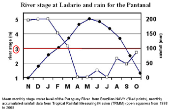
The process model (to be later developed - with additional sources of funding - using the INCA framework, an avant-garde analytical tool which has made important contributions to water management) of the hydrology and pollutant hydrochemistry of the region, using data gathered from the literature and through research and agency contacts in the area. The process model will eventually provide pollutant source apportionment and a heightened understanding of the hydrological and source controls on the ecological status of the water. The hydrological focus would be on the prediction of the extent and dynamics of the ‘flood wave’, which occurs when the principal rivers of the region overtop their restricting levees, taking into account data on groundwater levels, soil moisture deficits and local anecdotal data on response to flooding.
Click on image to enlarge
The chemical focus would be on the transport and transformation of nutrients (P, C and N) delivered to the water by urban and rural sources, taking into account municipal data on sewage loads and GIS data on land cover (e.g. from www.dgi.inpe.br) and anecdotal data on hotspots of pollution (e.g. from www.cpap.embrapa.br). The ecological focus would be on identifying stress metrics for the ecology as well as anecdotal data on fisheries from tourism guides and local landowners.

|
Updated: 23 Jan 2024, Content by: AV
|