 In the light of legislation such as the EU Water Framework Directive there is a need for simple models of hydrology and water quality that can be applied at a national scale to provide a broad risk assessment. The models help to fill gaps in monitoring data and can be used as screening tools to identify issues and geographic areas that require more detailed study. The models can also be used to provide an overview of the risks associated with future climate change.
We have developed a generic water balance model for Scotland that is based on the same principles as our catchment scale models, but that is applied at a coarser resolution of 1km2 and that focuses on calculating fluxes via different flow paths without spatial integration of the fluxes in relation to the stream network. This water balance model has been used to underpin the development of policies for abstraction regulation in Scotland, as well as underpinning a suite of chemical models for diffuse pollution. One specific example is NIRAMS (Nitrogen Risk Assessment Model for Scotland) which has been used to help support the designation of Nitrate Vulnerable Zones.
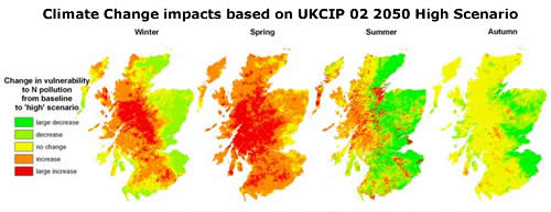
The national scale water balance model is also being used to explore the sensitivity of water resources to potential future changes in climate and to assess the inherent vulnerability of different geographic regions to N and P pollution.
Our research in this area focuses on:
- Providing national scale estimates of water fluxes and diffuse pollution to help underpin policy development
- Providing a mechanism for exploring climate change impacts
Who is working in this area?
- Sarah Dunn
- Martyn Futter
- Allan Lilly
- Andy Vinten
Keywords
- national scale, water balance model, water quality, climate change, risk assessment
|
Updated: 23 Jan 2024, Content by: MC
|

