


 The James Hutton Institute
This page is no longer updated. The Macaulay Land Use Research Institute joined forces with SCRI on 1 April 2011 to create The James Hutton Institute.
THE STATE OF SCOTLAND'S FARMED ENVIRONMENT 2005
21. ENVIRONMENTALLY SENSITIVE AREA SCHEME AND COUNTRYSIDE PREMIUM SCHEME
 Implementation
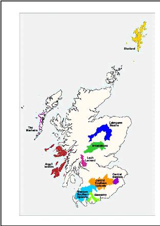
Five ESAs were launched in 1987: Breadalbane, Loch Lomond , the Stewartry, Whitlaw/Eildon in the Borders (to become the Central Borders), and the Machairs of the Uists, Benbecula, Barra and Vatersay, a narrow strip of western seaboard in the Western Isles. The precise delineation of the ESAs was determined by a working party of representatives from the Scottish Office Agriculture and Fisheries Department, The Countryside Commission for Scotland , and the Nature Conservancy Council. As part of the 1992 CAP reform, 5 new ESAs were created in 1993 and at the same time three of the existing ESAs had their boundaries extended. The 10 ESAs cover almost 1.5 million hectares, equivalent to approximately 19% of Scotland ’s land, with nearly 4100 potential participants. The scheme closed to new applicants in December 1999.
| ESA | Area (km2) |
|---|---|
Argyll Islands |
2641 |
Breadalbane |
1812 |
Cairngorms Straths |
2361 |
Central Borders |
351 |
Loch Lomond |
497 |
Machairs of Uists etc. |
181 |
Shetland Islands |
1465 |
Stewartry |
603 |
Central Southern Uplands |
2733 |
Western Southern Uplands |
2205 |
To achieve the above aims, landholders voluntarily entered the scheme and committed their land to an agreed management plan for 10 years, although there was a break clause after five years. Common grazings committees could also enter common land into the scheme, separate from crofters’ individual applications. The scheme had two tiers of payment:
- Tier 1 agreement, a basic level of payment was made for fulfilling certain requirements over the total area of eligible land on each farm or croft. These ‘ maintenance’ requirements aimed to prevent any decline in the current state of the land.
- Tier 2 payments, which were considerably higher than Tier 1, were designed to 'conserve, enhance or extend' prescribed habitats or features of conservation value, including archaeological sites. Payments were usually made on an area basis (including the rebuilding of dry-stone walls) but ‘headage’ payments were made for removal of stock from the holding and, for example, tree planting.
- Capital payments were also available e.g. for fencing required to achieve the Tier 2 aims.
However, there are a number of regional variations in this scheme. Firstly, the size of the cap on the total payable to any particular holding under Tier 1 and Tier 2 and the balance between Tier 1 and Tier 2 payments varied between ESAs, reflecting the size of landholdings and the number and type of Tier 2-eligible habitats in each ESA. For example, the initial caps on Tier 1 and Tier 2 annual payments in the Stewartry were, respectively, £1500 and £5000, in Breadalbane and Loch Lomond , £2000 and £4000 but in the crofting areas of the Machairs they were £1000 and £2000. The caps and payments were revised as the scheme progressed.
Secondly, while the Tier 1 management prescriptions were standard across all ESAs, there were differences under Tier 2 with each ESA having its own list of eligible habitats or features. These were broadly defined so that one definition would cover the wide range of vegetation types that constituted, say, ‘wetlands’ in the different ESAs. Most habitats/features were common to several ESA lists but there were regional variations, not only in the list as a whole but also for certain priority habitats/features that were considered to be particularly important in an ESA. For the latter, it was mandatory to enter a significant proportion of what was present on the holding into Tier 2. Other Tier 2 measures were optional but in both cases the areas to be managed were selected by the landholder, subject to SEERAD’s subsequent approval. An example of a regionalised Tier 2 measure is the set of highly specific options for the narrow strip of coastal land that formed the Machairs ESA of the Outer Islands . These options encouraged traditional forms of management on the machair plain and the conservation of the dunes that protect the plain. Other examples include an option to protect the catchments of basin mires in the Central Borders ESA and options for hedgerow management applied only in some southern ESAs where hedgerows are common.
A booklet specific to each ESA listed the eligible features/habitats and provided guidelines and prescriptions for their management, although these were usually identical for all ESAs. Regional differences for particular prescriptions were confined to stocking rates on moorlands (decided on a site by site basis) and in permitted dates for cutting and cultivation. Applicants marked the areas of each feature and its intended management in a Farm Conservation Plan along with the aims of that management, although these were often vague e.g. ‘improve the conservation value of…'.
Environmentally Area Scheme - evaluation >>