 Environmental Monitoring Sites
Under climate change scenarios, for Scotland it is predicted that:
- Winter will become wetter with more periods of high intensity rainfall.
- Winter will become milder with fewer frosts and lower snowfall.
- Summer will have an increased number and frequency of days with high temperatures.
We need to collect data to detect these changes and examine how and when this is happening. This data can be viewed, live, as it is streamed from field sites.
The data is used in the decision making process when planning site visits and maintenance schedules. It will inform outdoor enthusiasts of local conditions, and indicate when river levels become significantly high or low.
Recent work on the impacts of volcanic ash originating from the April 2010 eruption in Eyjafjallajökull (Iceland) on the natural resources of Scotland used both Glensaugh and Sourhope for comparing pre and post eruption stream data. Read the report.
 Meteorological data
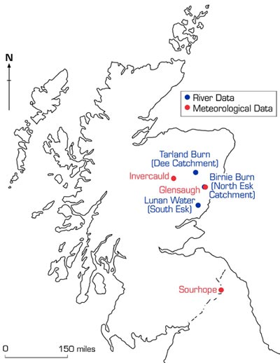
Meteorological data is currently available from our environmental monitoring sites located at:
- Glensaugh (Aberdeenshire),
- Sourhope (Scottish Borders), and
- Invercauld (Aberdeenshire).
River data
River depth measurements, water and air temperatures and conductivity data are collected from river monitoring sites located at:
- Tarland Burn (Deeside),
- Tarland Burn, Aboyne
- Tarland Burn, Coull
- Tarland Burn, Netherton
- Tarland Burn, Tarland Village
- Birnie Burn (Aberdeenshire), and
- Lunan (Angus)
