 The James Hutton Institute
This page is no longer updated. The Macaulay Land Use Research Institute joined forces with SCRI on 1 April 2011 to create The James Hutton Institute.
The James Hutton InstituteThis page is no longer updated. The Macaulay Land Use Research Institute joined forces with SCRI on 1 April 2011 to create The James Hutton Institute.
LSIRD NAPLIO CONFERENCE PAPERS
Location of optimal areas for the development of an alternative
livestock species: the cashmere goat
Kate Corcoran, Barry Dent, Julian Smith & Pablo Lara
SUMMARY
Optimal areas of location for the development of livestock
enterprises within the European Union can be identified based on a classification
methodology using ranking and weighting of physical, climatic and socio-economic
characteristics for areas being evaluated. Two less Favoured Areas (LFA)
in hill and upland situations in Andalucia in Spain and Scotland were classified
sub-regionally in order to identify optimal areas for the location and
development of cashmere goat production.
ARC/INFO Geographical Information System (GIS) facilitated the ranking and ordering of spatially variable characteristics and was an integral part of the overall enterprise location 'decision support system'. The technique of spatial overlay allowed areas coincident for optimal characteristics to be identified and mapped in sequence to produce a final map of optimal areas. The order of coverage overlay (thematic layers of information) was significant with areas where characteristics were judged to be most limiting, eliminated first. The order of coverage overlay was as follows:- LFA status (Sub-group 'Areas at Risk of Depopulation') overlaid with areas satisfying altitude > 400 ms. Areas satisfying both these criteria were then overlaid with climatic maps and resultant areas classified as optimal, sub-optimal or unsuitable. Administrative areas corresponding with the second overlay were identified and scored based on a number of socio-economic criteria to give a final map with a five category optimality range. The spatial units used in the analysis were the 'comarcas' in Spain and the 'region' in Scotland. Socio-economic factors considered in the administrative scoring process were: presence and level of sheep and goat subsidy; land area (SAU); goat and sheep population; milk and meat goat population; goat and sheep slaughter numbers; number and size of farms and population density.
The process was robust in firstly identifying areas
of suitability and secondly in providing a methodology which could take
account of changing levels in one or more characteristics.
INTRODUCTION
Structural adjustment is now firmly a feature of EU farming
and a both rural and farm diversification promoted widely through EU policy.
The policy context of the post Structural Funds reform period since 1988,
has been: firstly to move away from production centred support instruments
which, for the livestock sector has seen a high proportion of previous
support decoupled from output, though this has been in part replaced by
headage payments. A second post-reform measure seeks to provide the means
for a wider integrated rural development policy through support measures
targeted at designated Objective Areas, with Objectives 1 and 5B relating
directly to disadvantaged 'Less Favoured Areas' (LFA)s. For agriculture
in these areas this has resulted in funds being made available for diversification
of farm enterprises where enterprise options to provide viable farm-family
income are limited and where average incomes in LFAs are currently 50-70%
of those achieved in non-LFA areas (Commission of the European Communities,
1993). The impact of farm diversification to supplement farm income has
been disappointing and uptake low. While current policy seeks to encourage
diversification, a more integrated approach of extension support, enterprise
economic assessment and initial targeting of areas with a high probability
of success is necessary if more diversification is to occupy a permanent
place on farms. Policy makers need information or rules upon which to base
decisions on improving the uptake of alternative enterprises. This study
concentrated on developing a methodology for identification target optimal
areas for the alternative ruminant, the cashmere goat. The production fibre
and meat from cashmere goats represents a potentially sound extensive diversification
option (Milne, 1993; Corcoran, 1994). Optimal locations are likely to be
for those areas which provide most favourable conditions when the interaction
of physical, climatic and socio-economic characteristics are evaluated.
The hypothesis presented here is that 'if the optimal occurrence of characteristics
are spatially located and ranked, based on the scoring and weighting of
relevant factors, then areas which are 'most favourable' for a particular
enterprise can be positively identified and ranked.
Geographical Information Systems (GIS) provide effective
tools for this type of reasoned land evaluation processes through the development
of decision rule structures and predictive modeling (Eastman, 1993). Siddiqui,
Everett and Vieux, (1996) used a GIS spatial analytical hierarchy process
(AHP) to take into account regulatory restrictions, area attributes and
site assessment criteria provided by experts and/or users, for a preliminary
landfill site assessment in Cleveland County, Oklahoma. In the present
study, AHP ranking methodology using choice heuristics and selection rules,
was used to locate ideal areas for the development of cashmere goat enterprises.
These were Andalucia, Spain and Scotland, UK.
SPATIAL DECISION SUPPORT
Decision rules typically contain procedures for combining
criteria into a single composite index together with a statement of how
alternatives are to be compared using this index. They are structured in
the context of a specific objective. The nature of that objective serves
to guide the development of the structure used in a particular decision
rule and the relative weighting given to criteria used are in turn guided
by expert opinion. In the analysis of spatial or thematic information,
decisions on the selection and ranking of features within each thematic
layer and the order in which these layers of information are overlaid is
critical for the results generated. For spatial overlay using Boolean criteria
(/constraints), suitability solutions usually lie in the union or intersection
of conditions. In order to evaluate areas of suitability for cashmere goats
in Andalucia, the following spatial overlay sequence was used to select
areas of coincident and consistent high suitability: areas of favourable
LFA status/ risk of depopulation, Objective 1 or 5B status, altitude and
climate (favouring goat systems). Superimposed on these areas were administrative
areas (comarcas) each carrying an index of suitability based on
criterion scores and weightings of those factors considered to be essential
in the evaluation process. As factors were continuous, (less to more important)
a weighted linear combination in which weightings were applied to factors,
followed by a summation of results yielded the suitability scores (Eastman,
1993).
i.e. S = w ix i where s = suitability
wi = weight of factor I
xi - criterion
score of factor I
Scales upon which criteria scores were based were subjectively
standardised. The development of weights was based on a pairwise ranking
process developed by Satay (1977) using AHP where the weights sum to one.
Weights are derived from the comparison of the relative importance of the
two criteria involved in determining suitability for the stated objective
(Table 1). On a 9 point continuous scale, a value is given for the relative
importance of paired factors laid out in a matrix such that a high priority
rating is given a high score for the factor row (e.g. 7), whereas a low
relative rating for the factor row would be given an inverse score of 1/7
(Figure 1).
|
1/9 |
1/7 |
1/5 |
1/3 |
1 |
3 |
5 |
7 |
9 |
|
Extremely |
very |
strongly |
moderately |
equally |
moderately |
strongly |
very |
Extremely |
|
Less |
important |
More |
important |
Figure 1: The continuous Rating Scale
For Andalucia, the suitability score index was calculated
using the single objective 'areas which offer best potential for a cashmere
enterprise at the current time for each relevant
| Shp/goat
Systems |
Land Area | Climate | Sheep
pop |
Goat
pop |
Goat
Slaught. |
Sheep:
Goats |
Dairy:
Meat |
Farm size | Numberof Farms | Tradi-tion | |
| Sp/Goat
Systems |
1 |
7 |
5 |
2 |
2 |
3 |
1 |
1 |
5 |
5 |
1 |
| Land Area |
1 |
1 |
0.2 |
0.33 |
0.2 |
3 |
3 |
5 |
4 |
1 |
|
| Climate |
1 |
0.2 |
0.2 |
0.2 |
0.2 |
0.2 |
0.33 |
0.33 |
1 |
||
| Sheep
pop |
1 |
0.2 |
0.2 |
5 |
0.33 |
3 |
3 |
0.33 |
|||
| Goat
pop |
1 |
1 |
3 |
5 |
3 |
3 |
1 |
||||
| Goat
Slaught. |
1 |
5 |
2 |
3 |
3 |
1 |
|||||
| Sheep:
Goats |
1 |
0.33 |
1 |
1 |
0.33 |
||||||
| Dairy:
Meat |
1 |
3 |
3 |
2 |
|||||||
| Farm size |
1 |
1 |
0.33 |
||||||||
| NumberFarms |
1 |
0.33 |
|||||||||
| Tradition |
1 |
Table 1: Pairwise comparison matrix for assessing the comparative importance of factors
(Rating of the row factor relative to the column factor)
factor' (comarcas level), based on the multi-criteria
evaluation of factors shown in the row-column matrix in Table 1. A similar
pairwise comparison procedure was carried out for Scotland .
| Factor | Weight |
| Shp/goat systems | 0.445435 |
| Goat population | 0.193378 |
| GoatslaughterNos | 0.160414 |
| Dairy:Meat | 0.134655 |
| Land area | 0.132663 |
| Sheeppopulation | 0.120785 |
| Tradition | 0.107158 |
| Climate | 0.050226 |
| Sheep: goats | 0.039741 |
| Farm size | 0.039292 |
| Number farms | 0.03839 |
Table 2: Ranked Weights
Finally the procedure sums the weights within each column,
divides each co-efficient by the sum and then averages over all columns
to produce a best fit approximation set of weights. This procedure
achieves a good approximation with Satay's (1977) best fit, produced
by computing the principal eigenvector of the pairwise comparison matrix
(Table 2).
Suitability maps were produced for both areas in ARCVIEW following the
union of spatial and weighted attribute data. Spatial polygon data coverages
were digitised using ARC/INFO ADS at a scale of 1:1,000,000. At this scale
discrete farm polygons are lost and mapped output reflects potential at
a low resolution. The overlay procedure followed to compile the 'optimal
location' map is given in the APPENDIX.
RESULTS
The coverage overlay order in the UNION process and the
ITEMS chosen for reselection influenced the polygons satisfying the selection
criteria and the spatial distribution of selected polygons on the final
suitability map. The inclusion of 'Mountainous Areas' within the LFA selection
would have taken in additional tracts in Huelva, Cordoba, Jaen, Granada,
Almeria and the northern part of Malaga. However the addition of the constraint
of areas with an altitude greater than 400 metres was felt to allow the
'theme' of depopulation to be modeled at altitudes where hill farms exist.
The climate ranges selected were: 'cold and hot steppe' and 'temperate
warm and hot summer', these having to occur in areas above 400 metres.
No upper constraining limit of altitude was included in the evaluation
process although this constraint is valid and would have eliminated further
areas from the final suitability map.
An evaluation of land areas suitable for cashmere goat
enterprises in Andalucia., was carried out at the University of Cordoba
in 1996. This produced a high degree of consistency with areas identified
and provided validation of the AHP methodology (Lara, 1996). This ground-truthing
was essential when the weighting and ranking of factors was carried out
outside Andalucia.
Map 1
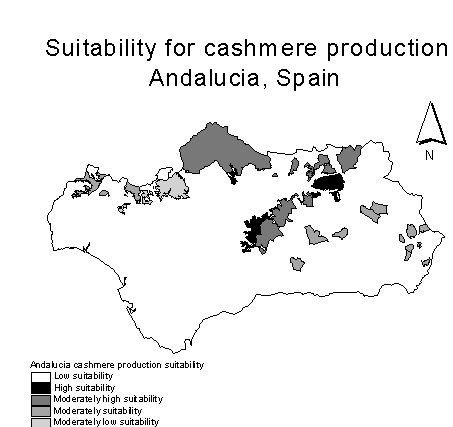
Map 1, includes areas in the following comarcas: Alhama,
Alto Almazora, Anavalo Occidental, Bajo Almazora, Baza, Campina Alta, Campina
del Norte, Campina del Sur, Campo Tabernas, El Condado, Guadix, Huescar,
Iznalloz, La Loma, La Sierra, La Sierra Norte, Pedroches, Penibetica, Sierra,
Sierra Cazorla and Sierra Morena. The factor 'common grazing' not relevant
in Andalucia, would serve to modify index scores in Northern Spain.
Map 2 indicates areas where goats might targeted under
the present 'no subsidy' regime in Scotland. In the absence of subsidy
paid on goats, LFA 'specialist sheep' was taken as a proxy of land use
suitability for fibre goat systems. Precipitation was then overlaid on
this 'composite' coverage with the rainfall range divided into six suitability
categories falling between 500 and 3000 mm. Areas with a rainfall above
1500 mm were considered least suitable with those between 500 - 1000 mm
suitable on a sliding scale. This product coverage was then overlaid with
the administrative regional boundaries which carried the suitability index
score for attribute agricultural data. The area with highest 'suitability'
lies in the north around Inverness where rainfall is lowest at 500 mm per
annum. Moving to the next suitable zone - 'fair to moderate suitability',
more extensive tracts of Highland Region, upland Tayside and the southern
part of Grampian Region were selected. These areas have a low to moderate
rainfall with high levels of extensive sheep systems. Areas in the west
in Highland Region, Argyll, Strathclyde and Ayrshire and in the north east
in Grampian Region, Fife, Central Region Lothian and borders have 'moderate
to poor' suitability ranking. This rank reflects a combination of factors
which scored low for goat production in these areas: high rainfall, poor
access to grazing or the presence of a high level of non-LFA farms made
up by arable, intensive livestock, or mixed farm types for example.
Map 3 shows areas of suitability within Scotland if subsidy
were extended to goats in line with levels applied in southern European
countries i.e. at 90% of sheep subsidy. LFA areas carrying Highland and
Island Enterprise attracts highest subsidy and scored highly. Map 3 reflects
the a situation where higher scoring, extensive specialist sheep target
areas, frequently to fall within areas of higher rainfall, which carry
a lower ranking. This gives an end-picture of higher suitability in northern
highland areas, becoming marginally less suitable moving south through
Argyll. Grampian, Central Region Tayside, Strathclyde, Dumfries and Galloway
and eastwards through the Borders region to carry a 'moderate' suitability
rank. The areas of Fife, East Lothian and Berwickshire have a 'least' suitability
allocation being the principal cereal growing areas of Scotland. Other
areas to the west in Ayrshire also carry a low suitability rank due to
a high concentration of dairying in the locality.
Map 2
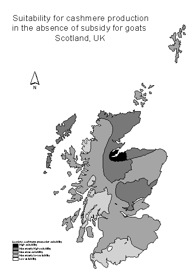
The Islands region varies in suitability ranking: Orkney, being lowland in type has a fair suitability based on lower levels of existing sheep production, while the opposite situation exists in the north in Shetland. The Western Isles have a high suitability rank due the high score given to common grazing in this area. The availability of common grazing and high sheep density offset the high negative rainfall score and small holding size which could reduce the suitability scoring. For Scotland expert opinion has suggested that areas with higher precipitation should be allocated lower scores at the pairwise ranking matrix stage.
Map 3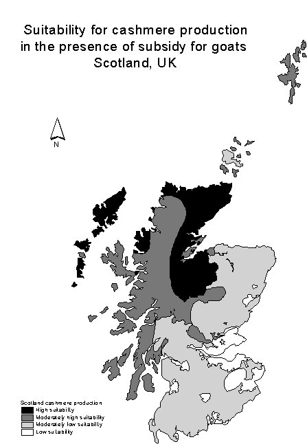
DISCUSSION
The process of spatial overlay and analytical hierarchy
process for indexing factors in the attribute evaluation was robust, firstly
in identifying areas of suitability and secondly in providing a methodology
which could take account of changing levels in one or more characteristics
by rerunning the overlay process and/or recalculating the best fit
set of weights. If the location of the optimal occurrence of characteristics
can be scored in this way and areas which are deemed 'most favourable'
for a particular enterprise identified, it follows that the process could
evaluate between competing enterprises for allocation of land resources
for example. Optimal location could also be alternatively given as area
where profit can be maximised from an enterprise; also fibre production
and carcasse weight or the farm-family labour resource could be used most
efficiently.
The methodology proved successful in identifying areas of suitability in Andalucia based on validation from within the area. The procedure is transferable in that local weighting and ranking of key factors which affect or influence area selection can be carried out for a range of livestock location exercises across Europe. Validation in Scotland was not possible at the current time due to the low goat population and number of goat enterprises.
CONCLUSIONS
Processes for evaluating information which helps decision makers and practitioners choose between alternatives are vital, if benefits derived from public monies are to maximised and unsuccessful schemes minimised. This study shows that initial target areas can be identified based on expert evaluation of current knowledge.
REFERENCES
Corcoran, K. (1994). Opportunities and Constraints for a European Fine Fibre Industry. Fine Fibre News (European Fine Fibre Network). No.3, pp 24-29, 1994.
Eastman, R.J., (1993). IDRISI GIS - Update Software User Manual, Version 4, Clarke University, Massachusetts, 01610, USA.
Commission of the European Communities, (1993). Farm Accountancy Data Network - The Agricultural Income Situation in Less Favoured Areas of the EC. Office for Official publications of the European Communities, L-2985 Luxembourg.
Environmental Systems Research Institute (ESRI), (1993). ARC/INFO User Manual.
Lara Velez, P. (1995). An internal study of areas of suitability for cashmere goat enterprises in Andalucia, University of Cordoba.
Milne, J.A. (1993). Economics of fibre Production. In Agriculture: Alternative animals for fibre production. EU Report No. EUR 14808 EN. (ed. A.J.F. Russel). pp 95-102.
Ministerio de Agricultura, Pesca y Alimentacion (1990). El Censo Agrario de 1989; Ganaderia - Ovinos y Caprinos (Livestock census of Spain - Sheep and Goats.)
Satay, T.L. (1977). A Scaling Method for Priorities in Hierarchical Structures, Journal of Mathematical Psychology, 15, 234-281.
Siddiqui, Everett and Vieux, (1996). Landfill Siting using Geographical Information Systems - A Demonstration, Journal of Environmental Engineering - ASCE, 1996, Vol. 122, No.6. pp.515-523.
The Scottish Office, 1996. Economic Report on Scottish
Agriculture. Agriculture and Fisheries Department.
Appendix.
| Step | Task |
| 1 | Digitise maps into coverages, edit and clean in ARCEDIT |
| 2 | Export coverages from ARCINFO ADS to ARCINFO |
| 3 | Add attribute data as *.DBF files and as ADDITEMS in TABLES |
| Overlay coverages and select out specific data from coverages as follows: | |
| 4 | UNION LFAAREAS ALTITUDE LFAALT1 |
| 6 | RESELECT LFAALT1 LFAALT2 POLY/RESEL LFAAREA_ID = 'Risk of depopulation' |
| RESELECT LFAALT2 LFAALT3 POLY/RESEL ALTITUDE_ID > 400 (metres) | |
| 7 | UNION CLIMATE LFAALT3 LFAALT4 |
| 8 | RESELECT LFAALT4 LFAALT5 POLY/ RESEL CLIMATE_ID = 'Cold steppe' CLIMATE_ID = 'Hot steppe' CLIMATE_ID = 'Temperate, warm/hot summer' |
| 5 | UNION COMARCAS LFAALT5 LFACOM1 |
| 9 | UNION REGION LFACOM1 LFACOM2 |
| 10 | Identify Ids for LFACOM2 records for unioned polygons in TABLES and ADDITEM 'suitability score' |
| 11 | Import files to ARCVIEW |
| 12 | Create PROJECT, VIEWS, THEMES, LEGENDS and LAYOUTS in ARCVIEW |
| 13 | Edit and print maps |
Procedure for Spatial Analysis of map and attribute data
Institute of Ecology and Resource Management, University of Edinburgh, Edinburgh, UK
University of Cordoba, Cordoba, Spain