| ||||||||||||||||||||||||||||||||||||||||||||||||||||||||||||||||||||||||||||||||||||||||
|
Field verification of SAR wet snow mapping in a non-Alpine environment Ron Caves, Andrew Hodson, Owen Turpin, Chris Clark, Rob Ferguson, Shaun Quegan Sheffield Centre for Earth Observation Science, The University of Sheffield, Hicks Building, Hounsfield Road, Sheffield S3 7RH, UK. Telephone: +44 114 2223704, Fax: +44 114 2223809, Email: R.Caves@sheffield.ac.uk FIELDWORK RESULTSHere we just summarise the results of fieldwork. A more detailed description is given in [4]. Missing coverage affects 13 of the 38 sites on one or other pass (6 layover, 1 radar shadow, 10 foreshortening). These are excluded from analysis, leaving a remainder of 25 sites. Elevation The sites range between 531 and 1208 m with most (20) concentrated between 600 and 900 m. Of the remainder, 3 sites lie above this range and 2 below. Aspect and slope A limited number of slopes were covered. All sites but one are distributed between NW and NE aspects and slope angles of 7° and 21°. Within these bounds the dis-tribution of aspect and slope is fairly uniform. Local incidence angle In both the descending and ascending images local inci-dence angles at field sites are uniformly distributed be-tween 20° and 41°. Snow extent During fieldwork the snowline lay at around 500 m. Of the sites visited, 75% were occupied by a continuous snow cover (with only minor vegetation and boulder protrusions above the snow surface), 20% were occu-pied by a discontinuous snow cover (with more exten-sive vegetation and boulder protrusions as well as sig-nificant bare ground exposures), whilst 5% were occu-pied by a sporadic snow cover. Temperature Lapse rates derived from data from Cairn Gorm summit (1245 m) and Aviemore (210 m) meteorological stations predict that the freezing line rose from 445 m to 545 m during the survey period. Based on this, no sites were above freezing for the descending pass when the tem-perature at Cairn Gorm summit was -5°C. Early on 12 March the temperature rose sharply and a rapid thaw set in. The temperature at Cairn Gorm sum-mit remained around 0° from 11:00 through to the time of the ascending pass at 22:10. Hence, it is likely that the snowpack was wet at all levels for this pass. Snow depth Mean snow depth varied between 5 cm and over a me-tre. Analysis revealed only a weak correlation between snow depth and elevation. This is indicative of the com-plexity of the snowpack. The limited range of slopes and aspects covered preclude an analysis of snow depth against these characteristics. The depth of melt between the descending and ascend-ing passes was calculated based on the lapse rates be-tween the Aviemore and Cairn Gorm summit meteoro-logical stations, a melt factor of 6 mm per degree per day and a snow density of 0.3 g cm-3. This gave 5 cm of melt at the lowest site reducing linearly to almost zero at the highest. During fieldwork the snow cover was noted to be as thin as 5 cm over parts of some sites, hence we would expect the lower of these areas to be no longer covered by snow for the ascending pass. Thermal state Dry/frozen conditions were found at the 12 sites above 704 m, while wet conditions were found at the 4 sites below 632m. In the intermediate zone (9 sites) an almost equal mix of wet and dry conditions was found. These observations imply that the actual freezing line is higher than that estimated from meteorological data. Analysis of intensity ratiosIntensity ratio images were formed by dividing the 11 and 12 March images by corresponding repeat pass im-ages taken towards the end of long dry periods in the summer (9 Aug. 1995 and 19 June 1996 respectively). Elevation dependence Fig. 1 (at end) plots the intensity ratios in the descending and ascending images against elevation for each site. The error bars represent one standard deviation (SD) of the intensity ratio. This was calculated based on the as-sumption that intensities are gamma distributed with an equivalent number of looks n determined by the amount of
smoothing. For the data analysed here a 2´2 pixel block average was first applied to reduce correlation. This changes the original 3-look data to approximately 5 equivalent looks. A 5´5 pixel Frost filter was then ap-plied to give a maximum of 125 equivalent looks. The SD of a gamma distributed random variable transformed to a dB scale is given by 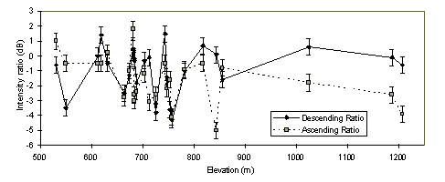 Fig 1: Intensity ratios (dB) for each site in the descending and ascending images plotted agaianst elevation. the error bars represent one standard deviation (0.55 dB) In Fig. 1, there is no simple pattern of variation of intensity ratio against elevation for either pass, particularly at mid elevations between 600 and 900 m where the inten-sity ratio is highly erratic. If the intensity ratio behaved the same as in alpine areas, we would expect all sites above the freezing line to have values around 0 dB (i.e. all but the lowest sites in the descending image), and all sites below it to have values of -3 dB or less (i.e. the remaining sites in the descending image and all sites in the ascending images). There does appear to be a broad correlation between the intensity ratios in the descending and ascending images, but this is not evident from any one site: at some the intensity ratio decreases between the descending and ascending passes while at others it increases. If we de-fine a significant change as being greater than 2s (1.1 dB) we can classify the sites into those exhibiting a sig-nificant increase, a significant decrease and no signifi-cant change. Above 856 m the majority of sites exhibit a significant decrease; indicating a change from dry to wet snow. Below 619 m the majority of sites exhibit a sig-nificant increase, possibly due to a decrease in the area covered by wet snow due to melting. The area between these elevations partially corresponds with the transition zone between dry and wet snow conditions. While all three classes occur within this area, the majority of sites exhibit no significant change. Histograms Interpretation of the results becomes clearer when histo-grams of the intensity ratios are examined. Fig. 2 shows histograms of the intensity ratio measured at field sites in the descending and ascending passes. The descending pass histogram has a main peak at 0 dB and a secondary peak at -4 dB. The ascending pass histogram has equal sized peaks at 0 dB and -3 dB. 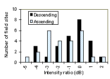 Fig 2: Histograms of the intensity ratio (dB) for the descending and ascending passes (bin size 1dB) These histograms accord with observations from both fieldwork and studies in alpine areas. The histograms are clearly bimodal with peaks occurring at data values associated with no-change (0 dB) and wet snow (-3 to -4 dB). Also, going from the descending to the ascending pass there is a marked increase in the latter peak, which we associate with wet snow, corresponding with an ex-pected increase in the wet snow area. Threshold selection The dip in both histograms at around -2 dB suggests that this could be a suitable choice of threshold for wet snow detection. To investigate this further, thresholds of -3 dB up to -1 dB were applied at intervals of 0.5 dB. Detec-tion occurs when the intensity ratio is less than or equal to the threshold. Fig. 3 plots the thresholds at which sites are first detected against elevation. 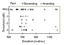 Fig. 3: Elevation dependence of detections. Sites are plotted where they are first detected as the threshold is raised. NULL indeictaes undected sites. With a -3 dB threshold, as used in the Alps, only four sites are detected in the descending image (elevation range 550 to 757 m) and five in the ascending (684 to 1208 m); one site is detected in both. At -2.5 dB just one extra site is detected in the descending image (664 m) while this and three other sites are detected in the as-cending (664 to 1187 m). At -2 dB no extra sites are detected in the descending image and two in the as-cending (688 and 747 m). At higher thresholds similar number of sites are detected in both images. The fact that twice as many sites are detected at or be-low -2 dB in the ascending image than in the descending image and that detected sites in the ascending image span a higher and greater range of elevation (664 to 1208 m) than those in the descending image (550 to 757 m), corresponds with the greater extent and elevation range of wet snow at the time of the ascending pass. However, if wet snow is the cause of backscatter change, it appears, particularly from the ascending im-age, that not all sites within the same elevation range are detected as wet snow even though snow is known to lie at these sites. We investigated whether this was due to differences in snow depth. Scatterplots (not shown) of intensity ratio against snow depth failed to reveal any relation between snow depth and intensity ratio. The Effect of Local Incidence Angle A possible alternative explanation is that intensity ratios contain some remnant effect of incidence angle. Ra-tioing of the snow and reference images removes the geometric effect of topography as long as registration is precise. However, as backscatter is dependent, amongst other things, on the local incidence angle, there should be some correlation between the intensity of the refer-ence and snow images and the local incidence angle. These relations were checked for the field sites using linear regression. The reference image intensity (dBs) and the local incidence angle (degrees) generated R2 values of 0.28 and 0.54 respectively for the descending and ascending images. The corresponding values when intensity ratio was plotted against local incidence angle were 0.09 and 0.19. These results confirm that there is some correlation between the reference image intensity and the local incidence angle and little, if any, correla-tion between the intensity ratio and the local incidence angle. Wet Snow detection in the Spey Basin To detect wet snow over the whole of the Spey basin the -2 dB threshold was applied to the intensity ratio images derived from the descending and ascending passes. Wet snow was detected over 50 and 161 km2 respectively in the descending and ascending images (5 and 15% of the imaged basin area). The greater area detected in the as-cending image accords with fieldwork observations and meteorological data. Note: the descending and ascend-ing passes cover slightly different parts of the basin (968 and 1053 km2 respectively). In both cases part of the western end of the basin is not imaged. However, the distribution of imaged basin area by elevation is similar for both. The elevation distribution of wet snow is plotted in Fig. 4. It shows the distribution of imaged area in 100 m ele-vation bands (right axis) and percentage area of wet snow detected within each elevation band (left axis) for both passes. The area within each elevation band stead-ily decreases as elevation increases. 48% of the basin lies above 500 m but less than 2% lies above 1000 m. 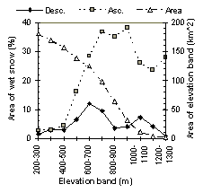 Fig. 4: Distribution of imaged area by 100m elevation bands and the persentage area of snow detected within each elevation band (-2dB threshold). For the descending pass, wet snow never covers more than 12% of an elevation band and is centred around 500 to 800 metres with little wet snow detected above or below this range. This accords with field observations of a 500 m snowline with wet snow up to 800 m. For the ascending pass there is considerably more wet snow at all elevations at or above the snowline and it is also more evenly distributed across these elevations. This accords with the freezing level being around the highest summits and a thaw occurring at all lower eleva-tions at the time of the pass. A comparison of the results from both passes with land cover information revealed that backscatter changes detected at elevations below 400 metres are mainly due to wind effects over open water or agricultural activity rather than wet snow. Such areas need to be masked out prior to estimation of wet snow covered area. THE EFFECT OF MISSING COVERAGEWe have already noted that geometric effects such as layover and foreshortening generate significant amounts of missing cover in ERS SAR images of areas of high relief. While this can be reduced by combining de-scending and ascending images the rapid changes in snow conditions occurring in the Spey negate the valid-ity and utility of any such combination. Hence, any in-terpretation of SAR wet snow maps of such basins must take the area affected by missing coverage into account. We quantify this below. Results are also given for the Tjaktjajaure basin in northern Sweden (67° N 17° E, area 2249 km2, elevation range 450 to 2058 m) which is also being studied within the HYDALP project. The missing coverage in a number of ERS scenes cov-ering the two basins was determined using SAR image simulations and local incidence angle maps derived from DEMs with a planimetric resolution of 50 m. These were used to generate layover, radar shadow, foreshort-ening and grazing masks. Table 1 (at end) lists the total area of missing coverage due to geometric effects, and the breakdown into areas affected by layover, radar shadow, foreshortening and grazing.
Table 1: Area (km2) of the Spey and Tjaktjajaure basins covered by different ERS passes and the percentage area of missing coverage due to gemetric effects including the breakdown into layover, radar shadow, foreshortening and grazing. The range position within each scene and the direction of the ERS pass are also listed. Within each scene the predominant source of missing coverage is foreshortening (between 67% and 85% of the total area of missing coverage) though layover is also significant (between 33% and 50%); note there is some overlap in the area affected by these two effects. Compared to layover and foreshortening the areas af-fected by radar shadow and grazing angles are insignifi-cant (less than 0.12%). This is as we would expect given the steep look angle of the ERS SAR. The total amount of missing coverage varies between 11.4% and 21.4% of imaged basin area. These are ap-preciable areas which any image classification must take into account. The variation in area is due to the range position of the basin within the scene and the spatial distribution of relief within the basin. At near range, where the incidence angle is steeper, layover and fore-shortening increase while radar shadow and grazing decrease. The effect of the spatial distribution of relief is apparent in the descending and ascending scenes 257/495 and 1143/15. In both scenes the Spey basin is imaged at mid range but the roughest topography is in the south east of the Spey. Hence, as the ERS SAR views to the right, more missing coverage occurs in the descending scene than in the ascending scene. The scenes of Tjaktjajaure exhibit approximately the same proportion of missing coverage as those of the Spey, even though the elevation range is 50% greater. This indicates that missing coverage is dependent more on the spatial distribution of relief than elevation range. Whenever descending and ascending scenes of the Spey basin are combined the missing coverage can be reduced to only 5.77 km2 (scenes 1143/15 and 2457/495) and 4.26 km2 (scenes 1143/244 and 2457/223), i.e. less than 0.5% of the basin. However, as already noted, such a combination is only useful when snow conditions remain stable over the one and a half days between acquisition of the two images. While this may occur during a cold period of no snow melt, it is by definition, less likely to occur during melt periods which are of interest for hy-drological modelling as is illustrated by the scenes ana-lysed in previous sections. Elevation Dependence of Missing Coverage As snow cover is elevation dependent, the elevation dependence of missing coverage must also be consid-ered. Fig. 5 plots the area of the Spey basin within 100 m elevation bands, and the percentage area of layover, foreshortening and total combined missing coverage per elevation band for one of the ERS scenes. 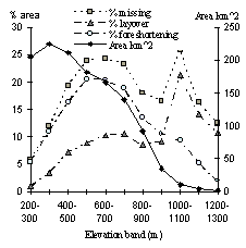 Fig. 5: Area of Spey basin within 100m elevation bands, and percentage area of layover, foreshortening and total combined missing coverage per elevation band occurring on ERS secene 2457/495. While missing coverage affects 17.5% of the basin as a whole there is a marked variation with elevation. Below 400 m, missing coverage affects at most 12% but at certain mid to high elevations it affects more than 20% and reaches a maximum of 25% between 1000 and 1100 m. The cause of missing coverage also varies with ele-vation. Missing coverage is mainly due to foreshorten-ing at mid elevations and layover at high elevations. The reason for this difference is due to the rounded topogra-phy, with the steepest slopes occurring at mid elevations and a plateau at higher elevations. In terms of total area, missing coverage most affects mid elevations with fore-shortening being the primary cause. This is a conse-quence of the decrease in the total area within elevation bands as elevation increases. Similar patterns of elevation dependence of missing coverage were observed to differing degrees in the other scenes. In certain cases the area of missing coverage was as great as 50% at particular elevations. The Effect of Incidence Angle on Missing Coverage An alternative solution to the problem of missing cover-age is to image the scene at a less steep incidence angle. The near range incidence angle in an ERS scene is about 19°. With Radarsat (and ENVISAT) it is possible to increase this to 40°. Table 2 shows how such an inci-dence angle would affect missing cover in two of the scenes listed in Table 1. Layover and foreshortening are now reduced to less than 1% of the basin area. Radar shadow and grazing increase but the total area of miss-ing cover is no more than a few percent.
Table 2: Percentage of the Spey and Tjaktjaure basins affected by missing cover when imaged with a near range incidence angle of 40°. abstract | introduction | fieldwork | :Results | conclusions | acknowledgements and references Last updated: 13th October, 1998 by Roger Dunham |

 This page has been mothballed.