Land Allocation Decision Support System
Remote Sensing
Remote Sensing Images
Evaluating the environmental impact of mountain-sport's in Scotland
Combining photography and videography to define soil sampling frameworks
Test Sites
Low-cost Site Characterisation
Up to 80% of the cost of deploying GIS-based land-use planning tools is in the spatial data capture, thus it is important that, methods for minimising costs while maintaining acceptable accuracy should be investigated.
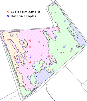
Test sites were ground surveyed for soil properties at four times the sampling density previously employed (4 per ha) using a stratified-random sampling strategy, with the number of random points proportional to the field size.
This was facilitated by the use of a dGPS/portable GIS system that allowed sample sites generated within the LADSS GIS to be located in the field to an accuracy of +/- 1m.
classification from remotely sensed imagery.
In addition to the randomly located points a further set of points located on a 100m grid were collected as a validation set. Geostatistical interpolation methods were used to create maps of soil properties using sampling densities of 0.5, 1, 2 and 4 per ha. Tested against the validation sets these give an estimate of the trade-off between accuracy and sampling density.
One possible way to improve the accuracy of prediction for a fixed sampling density is to bring in a secondary data source. Such sources include digital elevation models or remote-sensed imagery. Remotely sensed data has been used at the Newton-Rigg test site to provide within-field stratification for the survey. See the study Combining Metric Aerial Photography and Near-infrared Videography to Define Within-field Soil Sampling Frameworks and the paper of the same name for more information.

