Land Allocation Decision Support System
Monitoring mountain-sport's environmental impact: Evaluating the potential of remote sensing in Scotland (Glenshee)
Navigation: rationale | 1. original | 2. segmentation | 3. classification | 4. grass | 5. heather | 6. peat | 7. mineral | 8. stability | 9. interpretation | 10. future
[an error occurred while processing this directive]Rationale
Scottish mountains are under increasing pressure from their own popularity. This case study and the accompanying book chapter of the same title outline methods by which remote sensing can be used to monitor the human impact on fragile mountain ecosystems.
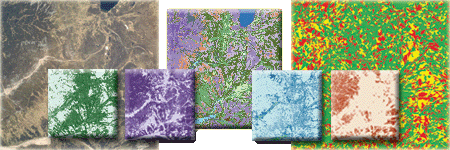
It is possible to monitor a remote area more efficiently using aerial imagary to locate specific, damaged areas or areas of high risk. This decreases the need for expensive ground based studies whilst providing a visual archive and data source for the future. A simple but effective management support tool can be developed by combining the aerial imagary with a digital elevation model, inside a GIS (Geographic Information System). This case study concentrates on the Glenshee ski area looking specifically at ski damage, but the ideas can be applied to any natural resource management situation.
Follow the links 1 to 10 to view the methods, results and interpretation for this study.

